REMOTE MANAGEMENT, MONITORING AND VERIFICATION SYSTEM (RMMV)
THE CHALLENGE
Violent conflicts and consequences of the global pandemic severely reduce monitoring possibilities in international development projects. The limits for onsite staff presence due to travel constraints or physical distancing restrict the control of project quality and progress. Remote Management, Monitoring and Verification (RMMV) Systems with integrated data collection processes have therefore become indispensable components in this field.
When planning to monitor project activities, stakeholders face an overwhelming choice of default monitoring tools. In the context of increasing data complexity and decentralized project activities, many tools do not meet the variety of remote monitoring requirements in everyday project management.
Our approach
GFA B.I.S. has therefore developed the Remote Management, Monitoring and Verification (RMMV) system DACOTA. It is characterized by a modular architecture, adaptability, as well as intuitive usability.
DACOTA enables to track and manage project activities by
- seamlessly integrating data collection tools and access to the project database
- displaying project activities and key information on a customizable map
- visualizing key analytics and performance indicators on tailored dashboards
With this overall concept, DACOTA enables project stakeholders to continuously monitor trends and progress without having to compromise on more detailed layers.
Next to the adaptability on the technical side, we equally prioritize the sustainability and longevity of our solution:
- After a successful implementation, DACOTA is fully handed over to our clients without charging recurring fees. We offer highly automated deployments to enable local IT administrators to maintain the application in the long term.
- As we exclusively employ open source components, no license costs are charged.
- Recognizing data privacy-regulations, requirements of donor organizations, and potential geopolitical shifts, DACOTA can be installed on any server worldwide.
DACOTA has been implemented to respond to remote management, monitoring and verification requirements of various projects financed by GIZ and KfW. Due to its modular design, DACOTA can be fully customized to the project’s requirements on short notice.
DACOTA IN DETAIL
 DACOTA is made up of interchangeable components which are combined to meet the RMMV needs of the individual project.
On the data input side, DACOTA supports a wide range of external data sources, such as Excel or SQL Databases. This allows a frictionless import of existing data and previous monitoring solutions. Integrating complementary products such as mobile data collection tools (e.g. World Bank’s “Survey Solution ®”) enables organizations to efficiently respond to day-to-day monitoring needs. Local staff or third parties are equipped with mobile devices (e.g. tablets, smartphones) to regularly collect information on site. The data is automatically geo-referenced and timestamped, whereas uploaded photographs or videos verify the information. As soon as internet connectivity is available the collected data can be uploaded into DACOTA– permitting project stakeholders to manage, monitor, verify and analyze all collected information within one system.
DACOTA’s user interface is based on the principles of Google’s Material Design. It includes a search and browse function throughout all imported data with filters and flexible sorting. It allows to manage an unlimited number of data entries, attachments, or notes and enables users to track changes and switch through historical values.
In order to analyze and visualize complex project data, we integrated customized dashboards and reporting tools into DACOTA. These permit to track the status and progress of all project activities, as well as funds and key performance indicators. A variety of advanced visualization options allow to easily filter, aggregate, and analyze data. As all data is exportable at any time, DACOTA enables the generation of progress reports that fulfill different stakeholder requirements.
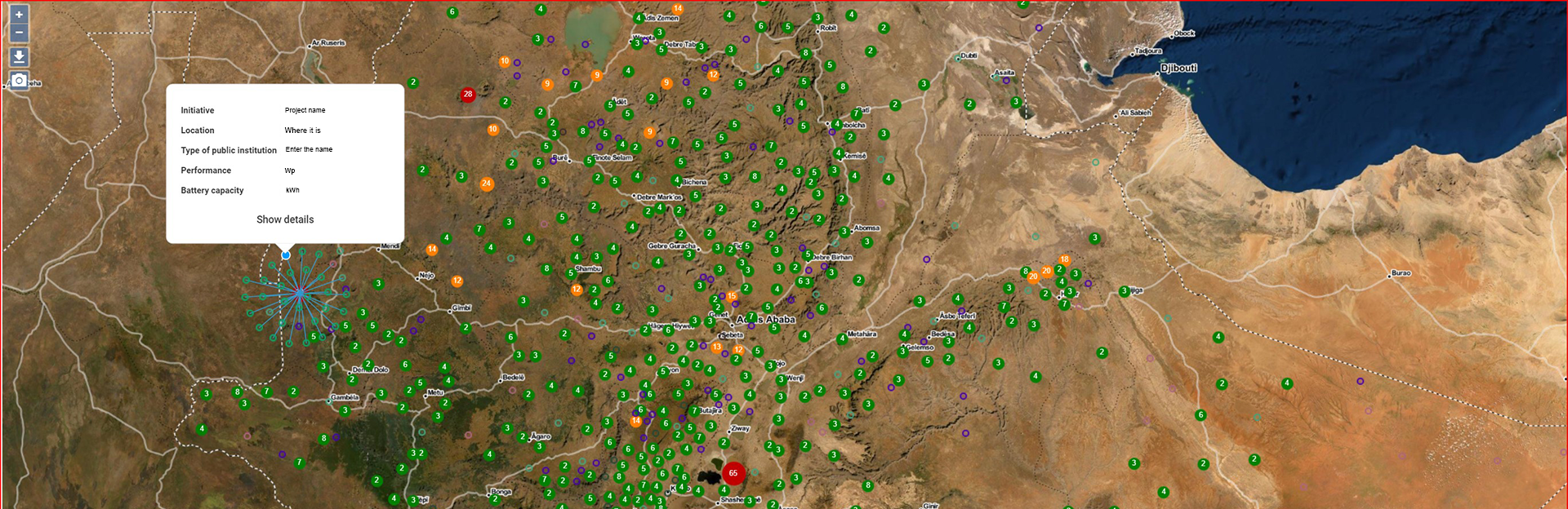
One of DACOTA’s core features is the mapping view. Geo-referenced project data entries are displayed and selectable on a customized map. By default, base layers include OpenStreetMap, a landscape relief and satellite imagery. The integration of overlapping layers such as national park boundaries, administrative boundaries or current vegetation covers, enables to put the location data into different contexts. Geo referenced data are displayed on top of these layers, providing popup boxes with customized core information and access to detailed view of the backing data sets.
Various functionalities are available for managing data access rights in DACOTA. Single users or groups can be given permissions to read, write or create new entries without modifying existing ones. Teams can own data sets permitting only them to have access to it, whereas data entered by certain users may require authorization from a superior before permanently entering the system.
Our Scrum derived development process is agile, iterative, user centric, and test driven. Short development iterations give our customers frequent opportunities to try the current state of their tailor-made product and to provide us with feedback so that we can make it fit their needs even better.
We ensure that our software is of the highest quality with automated tests and code reviews, and by employing cutting edge version management and internal collaboration systems.